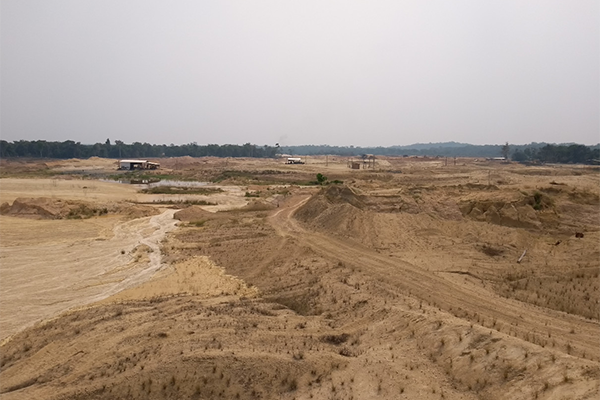
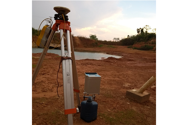
Geological-geophysical investigation of the Alta Floresta Gold Province
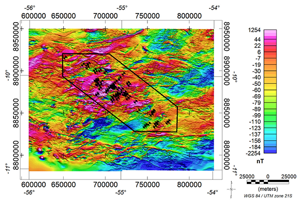
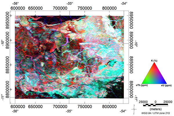
Geological and geophysical surveys investigate Brazilian territory since the 1970s. However, less than a third of the country’s mineral potential has been explored to this day. Geophysics increasingly becomes an essential asset in mineral exploration. It is presented here as a research tool for one of the areas with the most promising exploratory potential in the country: the Alta Floresta Gold Province, north of the Mato Grosso State. This province, which has been the target of recurrent discoveries of new deposits of Au and Cu mineralized from porphyry intrusions, shows itself as the area to be deciphered in a new exploratory race. Geophysical and geological analyzes are the focus of this initiative. The integration of airborne magnetic and gamma-ray spectrometry data with ground gravity, geological and structural observations will allow the proposition of geological-geophysical models of known targets and the proposition of new potential targets, in addition to the contribution to the knowledge of the evolution of this region still widely discussed by the scientific community.
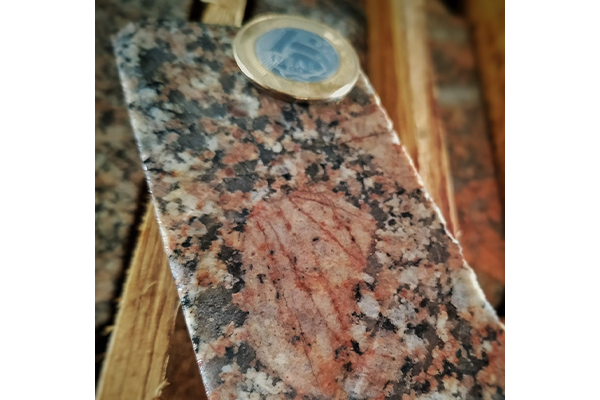
Mineral chemistry of hydrothermal and igneous minerals using Electronic Microprobe in gold deposits in the Province of Alta Floresta (MT), Amazon Craton
This project aims to characterize the hydrothermal mineral phases of Paleoproterozoic gold deposits in the Alta Floresta Gold Province (AFGP), south of the Amazonian Craton, using an Electron Microscope. It will obtain the in situ chemical composition of several minerals like muscovite, sericite, chlorite, rutile, apatite, feldspar, amphibole and magnetite. We will determine trace elements in sulfides (e.g. pyrite, chalcopyrite), separating the different mineralized zones in a single deposit. This procedure will reveal significant differences between deposits belonging to the same province, distinguishing fertile from sterile zones. By quantifying trace elements in sulfides (e.g. Cu, Co, Ni, Zn, Pb, Ag, Au, Bi, W, Sn, Al, Fe, REE), we will understand the mechanisms of ore precipitation in the different gold deposits of the province. In this scope, the mineral chemistry studies proposed for the gold deposits of the AFGP will allow the understanding of the physical-chemical conditions of their Paleoproterozoic magma-hydrothermal systems responsible for the precipitation of gold. This approach will allow (1) characterizing the compositional variation of hydrothermal minerals; (2) estimating the pressure and temperature conditions necessary for operants during the maintenance of the hydrothermal system; (3) determining conditions of fO2 and fS2 of the mineralizing fluid; (4) understanding the compositional variation of the fluid. Muscovite, sericite and chlorite are key minerals in this project, as they correspond to important hydrothermal phases, spatially and temporally related to the mineralized zones of the AFGP.
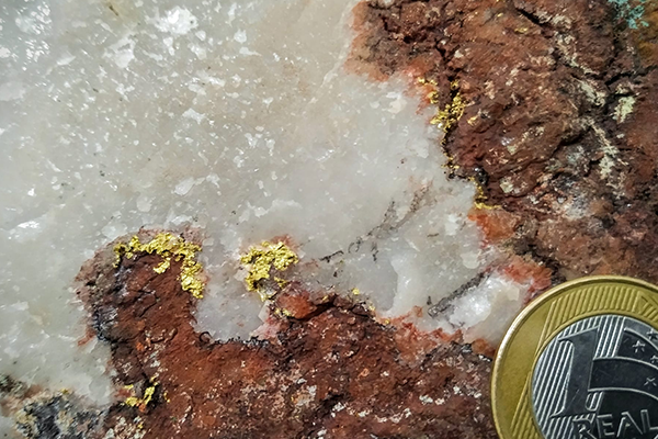
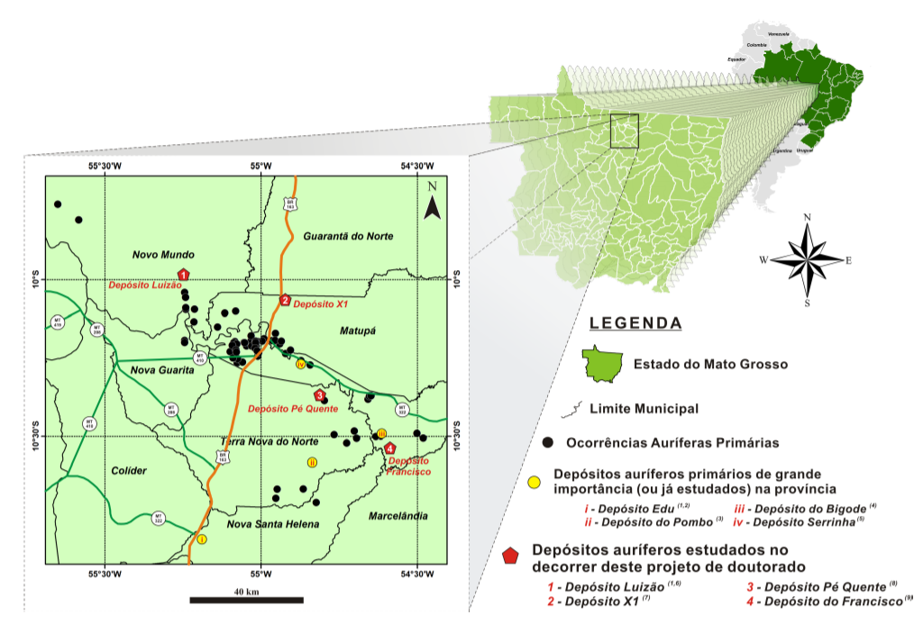
Paleoproterozoic magmatic-hydrothermal auriferous systems of the Alta Floresta (MT) Province, Amazonian Craton: geological context, geochemical signatures, stable isotopes and fluid regime
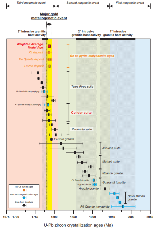
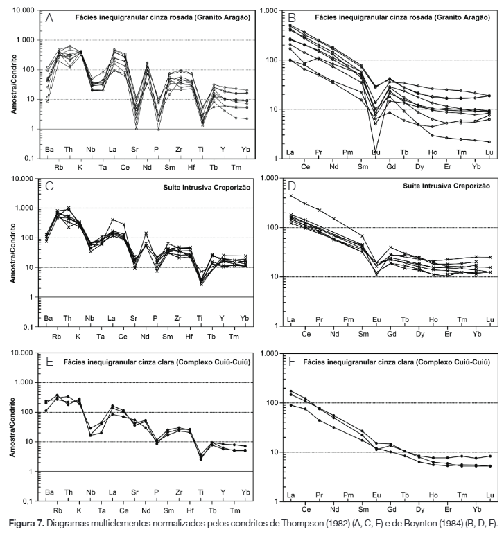
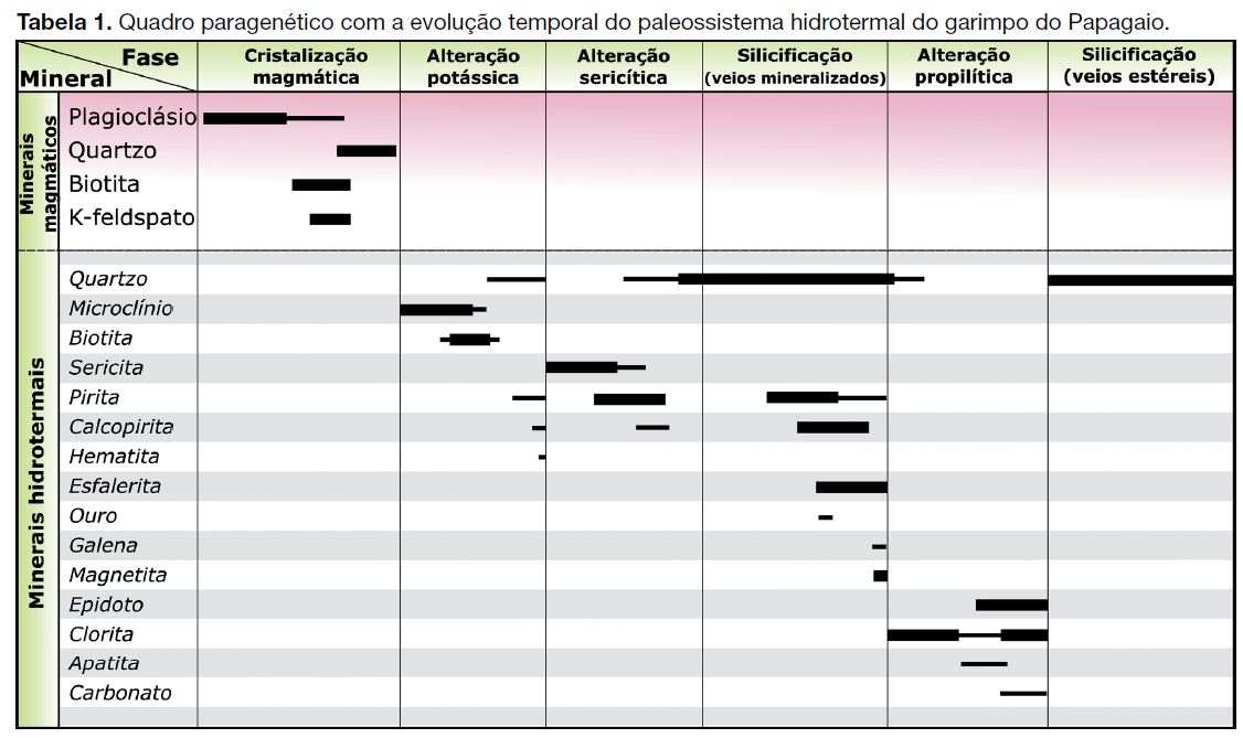
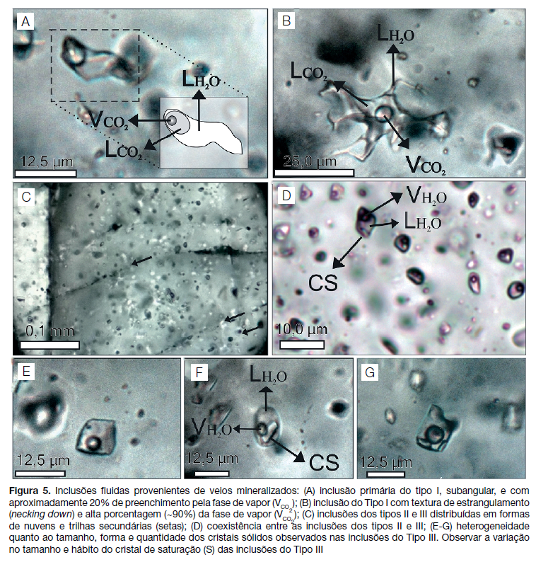
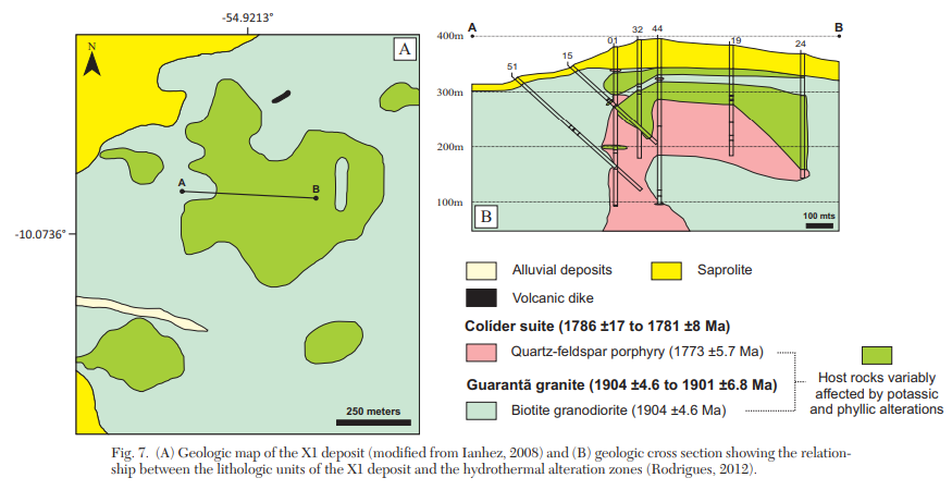
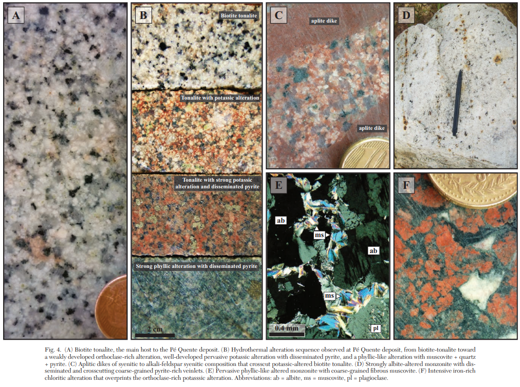
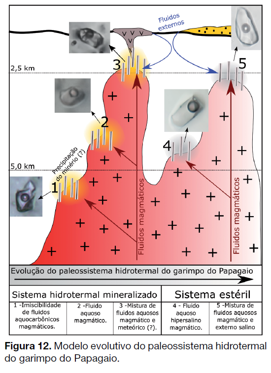
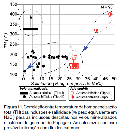
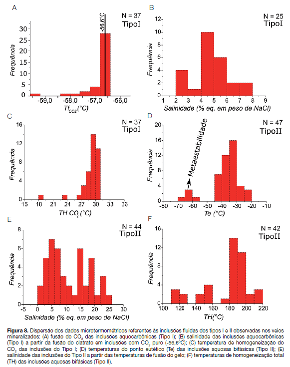
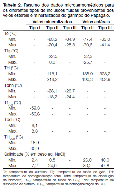
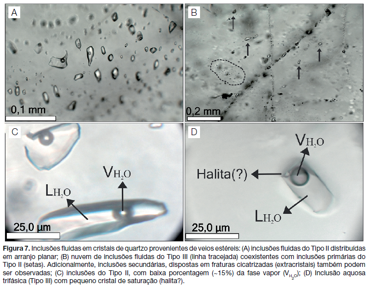
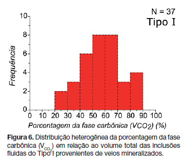
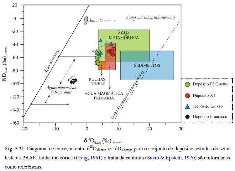
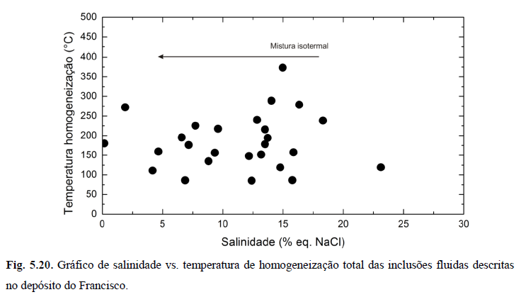
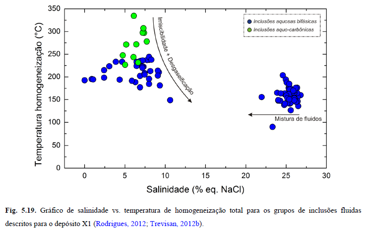
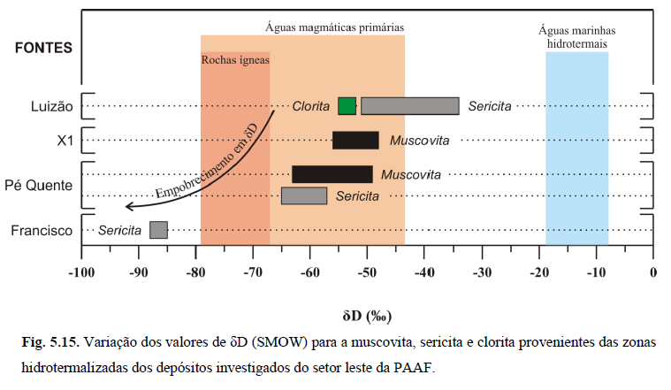
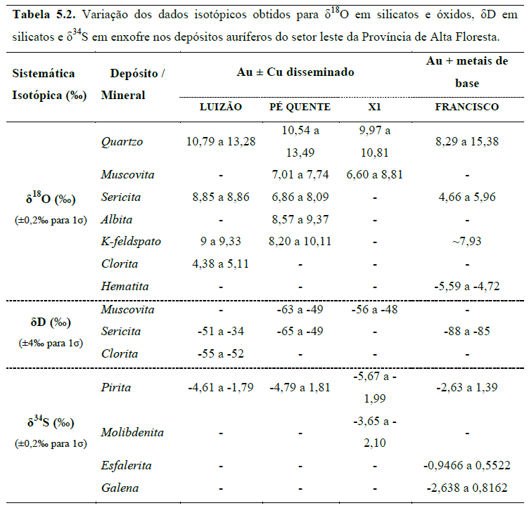
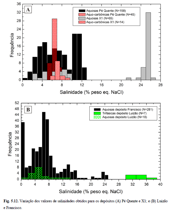
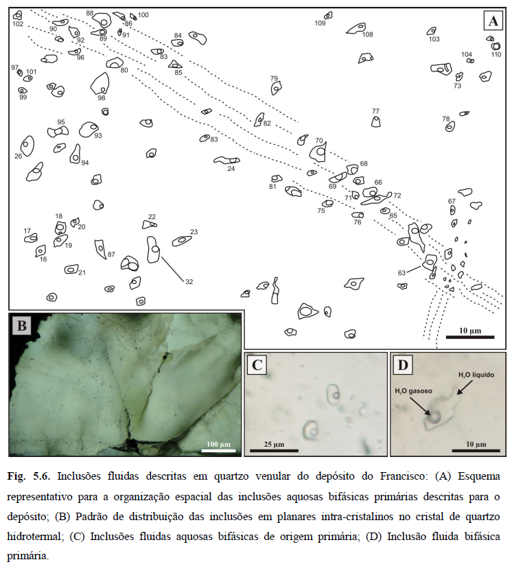
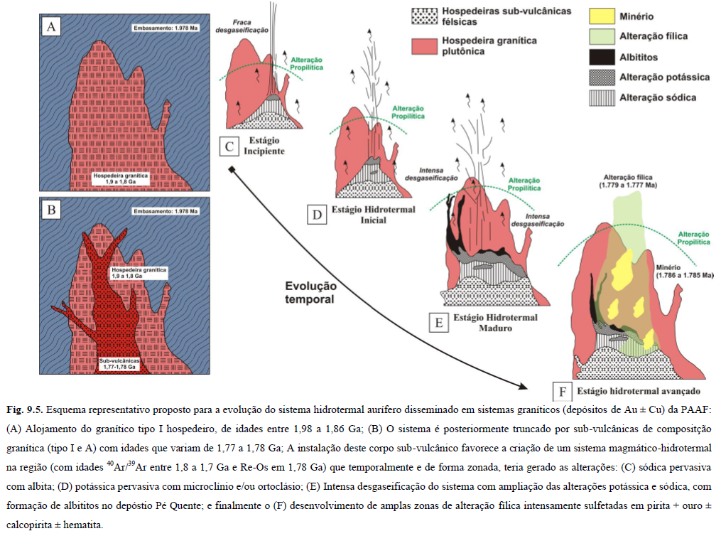
The Alta Floresta Aurífera Province (AFGP) lies in the southern segment of the Amazonian Craton (north of Mato Grosso State), consisting of numerous Paleoproterozoic plutonic and volcanic units. These units host more than a hundred small (<5t) and medium to small gold deposits moderate content. In the AFGP, the mineralizations form four groups: (1) disseminated Au ± Cu; (2) structurally controlled Au ± Cu; (3) structurally controlled Au ± Cu ± Mo; and (4) structurally controlled Au + Pb + Zn ± Cu. Re-Os ages and sulfide indicate that these mineralizations belong to the group (1), formed during a single Estaterian event, in 1,786 ± 3.2 Ma. However, this work has positioned these auriferous systems within a magmatic-hydrothermal context on several crustal levels. In the AFGP, Paleoproterozoic calcium-alkaline pluton-volcanic units predominate, many hosting gold mineralizations. The Pé Quente and Matupá suites, the Novo Mundo, the Aragão, the Guarantã, the Nhanduand the Peixoto, summed to the Colíder group, are examples of such hosts. It is essential to individualize magmatic events, so as to comprehend the geodynamics and metallogenesis of the AFGP eastern segment. However, this approach is limited due to a lack of lithogeochemical, geochronological, isotope and mineral chemistry data in the different units hosting gold mineralizations. This project, therefore, has the goal of understanding the role of felsic magmatism in the genesis of gold mineralizations in the eastern sector of the Alta Floresta Gold Province. Within this scope, the project has two main axes: (1) characterization of the plutonic-volcanic units of regional geotectonic and metallogenetic interest, through geological mapping, total rock geochemistry and U-Pb dating in zircon; and (2) individualization of geological attributes of the province’s gold mineralizations, through petrography and MEV (host, sequencing of hydrothermal alteration and ore paragenesis), fluid inclusions and isotopic signatures of the ore and hydrothermal alteration minerals (e.g. H, O and S). This approach will allow a more precise detail of the genetic models proposed for the province’s magmatic-hydrothermal gold systems.
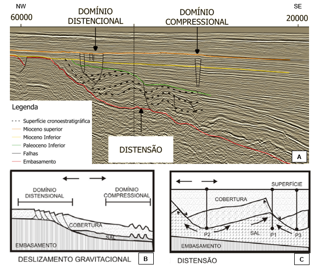
Neotectonic Front
High-Resolution Magnetostratigraphy and Cycle Estratigraphy of Eocretaceous Sections (Hauterivian-Barremian) of the Basins of the East Brazilian Margin
The sedimentary basins in the east/southeastern Brazil have their origin and evolution bound to the Gondwana breaking processes and the South Atlantic opening. In general, at least four tectonic stages suggest explanations for this process: Pre-rift (Juro-Cretaceous); Rift (Eocretaceous); Post-rift (Eocretaceous / Aptian) and Drift (Eocretaceous / Albian to the recent one). The Cretaceous was a period characterized by hot weather, without permanent ice caps at the poles and very peculiar paleoceanographic conditions that favoured several periods of extensive deposition of organic matter in ocean basins. Most of the Lower Cretaceous available data comes from pelagic sections of excellent stratigraphic resolution and continuity. However, shallow and continental environments are worse characterized. Detailed studies of these regions are essential to evaluate the impact of climatic and oceanographic events on a global scale. The objective here is to establish a high-resolution stratigraphic framework for the sessions between the Hauterivian and Aptian (Rift and Post-rift stages), from the east and southeast margins, comprising the basins from Sergipe-Alagoas to Santos. We intend to expand the knowledge about the paleoenvironmental and climatic conditions, the influence of orbital parameters on the rift (continental) records and the transitional phases of these basins. To achieve it, we will carry out sedimentology, lithostratigraphy, geochemical, isotope and magnetostratigraphy analyzes. The study subjects will be testimonies, well-log data, and outcrops along the eastern Brazilian basins. Also, we will compare and correlate the investigated sections with others of the same age in the Umbria-Marche basin linked to the evolution of the paleocean Tethys. We expect to recognize orbital cycles in the continental sessions (rift and transitional phases). These cycles will promote an effective high-resolution tool for stratigraphic and correlation studies between the records of the rift and transitional phases of the Brazilian east bank, including the rock packages linked to the Santos and Campos pre-salt reservoirs.
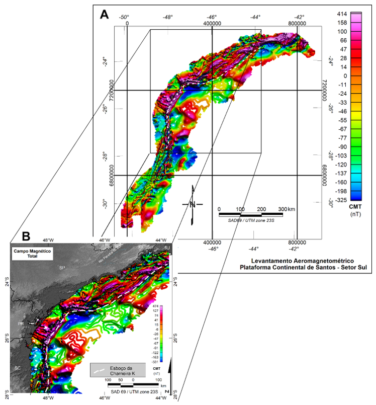
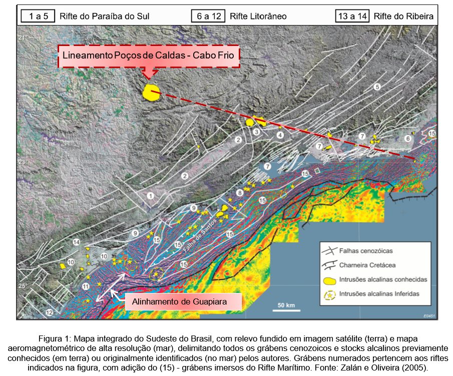
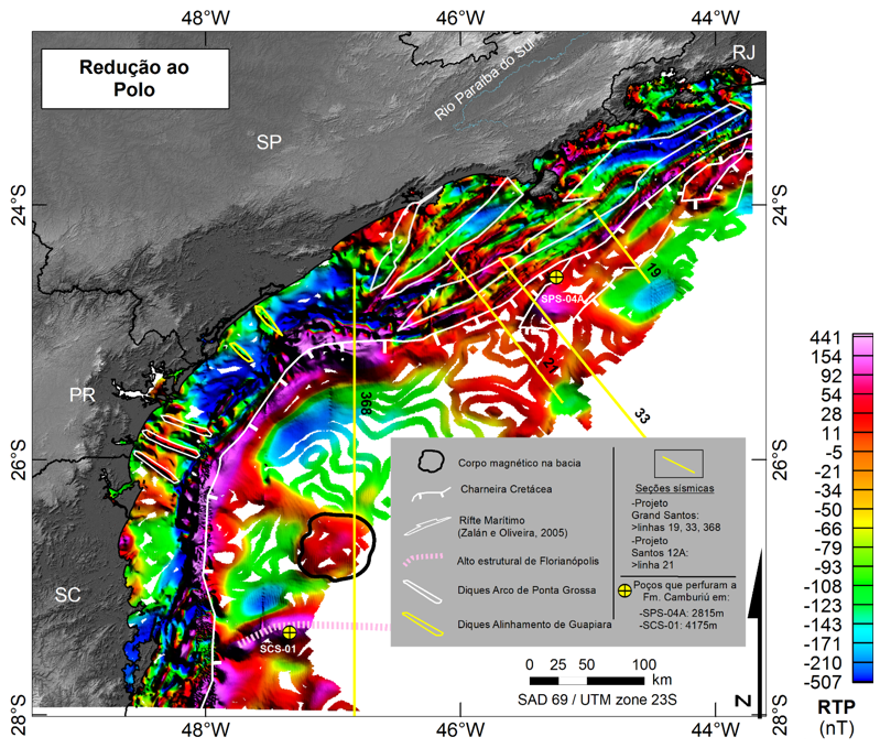
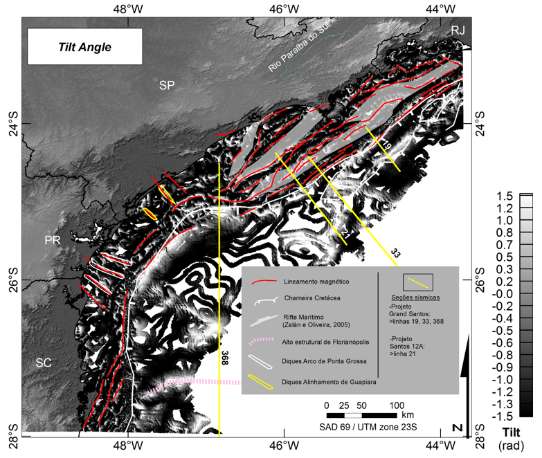
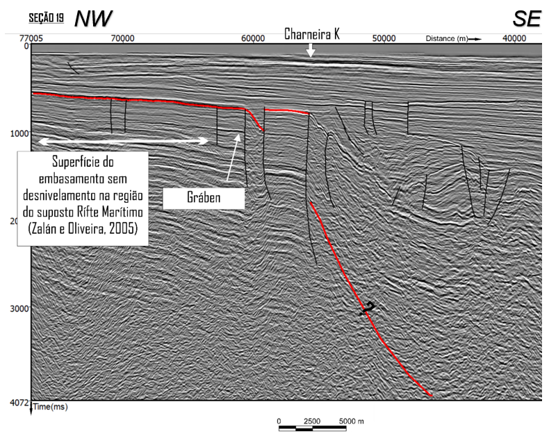
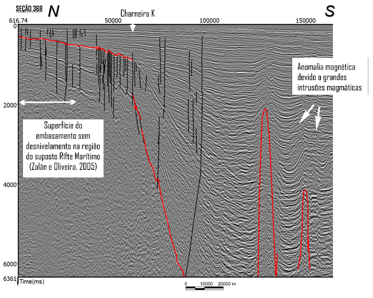
Tectonic-sedimentary Evolution and Paleogeography of the Santos Continental Shelf – Continental Margin of Southeast Brazil
This project seeks to investigate the origin and evolution of the tectonic-sedimentary structure of the internal and medium continental platform of Santos. In this context, both platforms represent the portion located between the coastline and the cretaceous hinge (structural limit between the Santos Basin and the continental platform. The investigations will use seismic, well-log, magnetic and gravity data. With those, we will study Mesozoic and Cenozoic tectonism, sedimentary filling (continental and marine) and volcanism in the area. The data acquisition will occur through systematic structural mapping and its correlation with published data and the available seismological networks. The investigation of potential mineral and environmental resources is also an expected side result of this project.
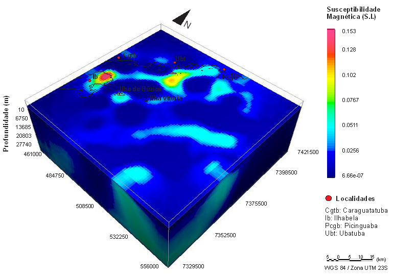
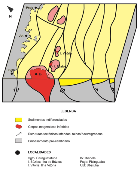
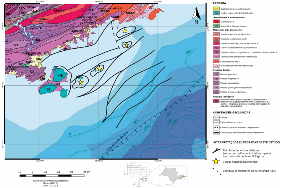
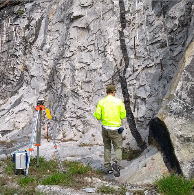
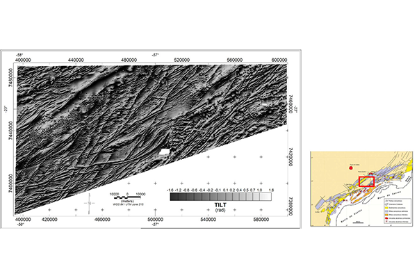
Tectonics and Mesozoic-Cenozoic Sedimentation of the Serra do Mar-Continental Continental System of Santos
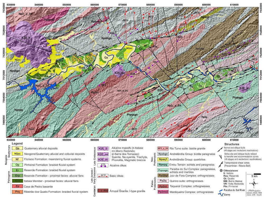
This investigation has its limits between Peruíbe (SP) and Maricá (RJ) and between the coast and the Paraíba do Sul river valley. The Precambrian rocks that make up the study area display orthoderivate and paragnassic complexes, and intrusive suites, inserted in the Embu and Coastal Complexes domains of the Ribeira Range. These rocks are aligned along with the NE-SW regional trend, being controlled or cut obliquely by ductile shear zones in the same direction. The Mesozoic and Cenozoic evolution displays at least four significant stages of uplift/failure in the Serra do Mar. We intend to identify, characterize and map the Serra do Mar main fault systems of 1:250,000 to 1:500,000, emphasizing brittle structures. We will use magnetic, gamma-ray spectrometry, morphostructural lineaments, and field data analysis. There is no overlap between geophysical and morphostructural features. Systematic field surveys should confirm the nature, kinematics and structural styles of the main features identified. The expected results will fill important gaps regarding the regional mapping of Serra do Mar structures, especially those of a brittle nature, linked to contemporary tectonic events and after the Gondwana breakdown. They also will relate the origin, tectonic and geomorphological evolution of this sector in southeastern Brazil.
Volcanism & Geohazards Front
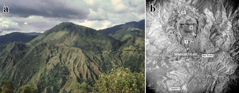
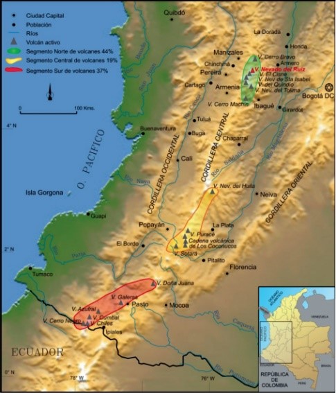
Volcanic monitoring through the integration of geophysical signatures in Colombia
The volcanic activity is part of the daily life of the Colombian population. The volcanoes in its landscape bring socio-economic benefits and coexistence with geological hazards. The movement of magma within the volcanic system causes variations of different natures in the environment. Its redistribution and temperature change the local magnetic field, as well as causing small variations in the topography. Depending on the rocks thermal coefficients, the magma intrusion heat can reach the surface and be mapped. Fluid and magma movements cause the release of elastic energy, culminating in earthquakes of varying magnitudes. This proposal addresses these properties at the Cerro Machin volcano in the Colombian Andes Central Cordillera. We will install a mesh of low-cost magnetometer in the volcano region, which will produce maps of temporal variation of the magnetic field. These maps will integrate with thermal, InSAR and seismological data. Such integration will base the modelling for the evolution of the volcanic system. Finally, we will use Machine Learning (ML) tools to perform volcanic activity predictive analyzes of the Cerro Machin.
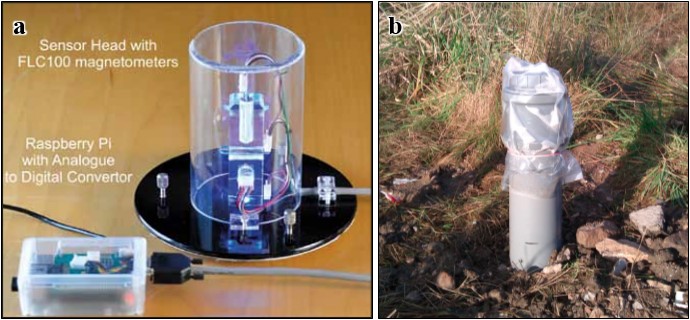
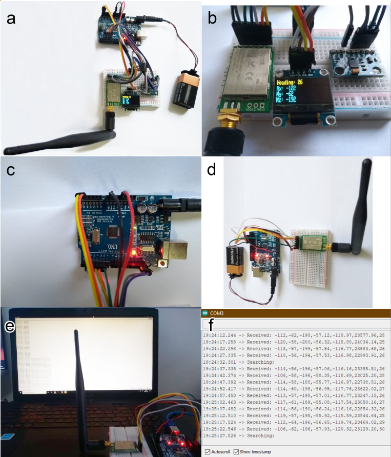
AuroraWatch UK – Magnetometer
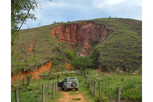
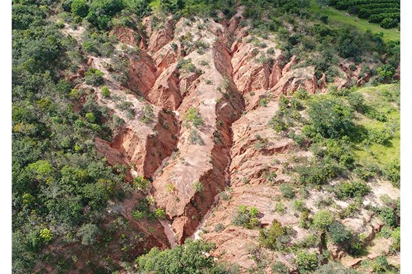
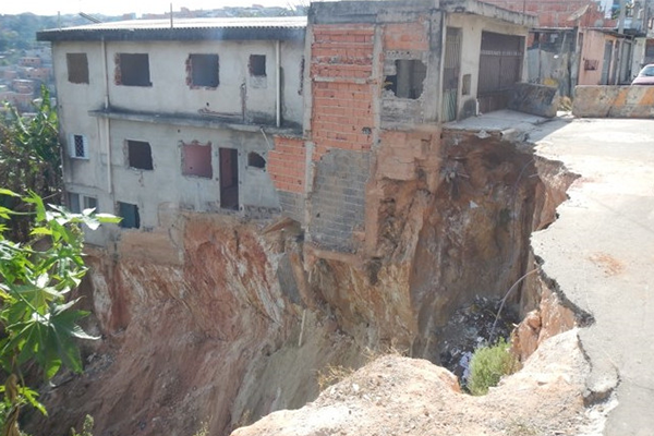
Use of geotechnologies applied to the study and analysis of gullies
Unmanned Airborne Vehicles (UAVs) have been used for decades with primarily military purposes. Its availability for scientific and other public purposes is, however, relatively recent. This technology uses digital photogrammetry techniques and software based on Structure from Motion (SfM) for several purposes. Monitoring and prevention of geological and hydrological events that cause losses to society are examples of such purposes. This project will characterize and monitor gullies present in the Anhembi and Botucatu municipalities, São Paulo State countryside, Brazil. To do so, we will integrate high-resolution multitemporal imaging from UAVs and orbital platforms. By measuring the samples reflectances from affected and non-affected soils, added to associated geomorphological signatures, we intend to intermediate the two platforms data. In this context, we will monitor and evaluate the erosions evolution, defining their growth rate (speed) and estimate the volume of soil carried. Also, we will analyze the behaviour of gullies at different times of the year (drought, intermediate and rainy periods) and cross the data (geological, geomorphological, land use and occupation) to support the understanding of the susceptibility of a given land to erosion.
Environmental Front
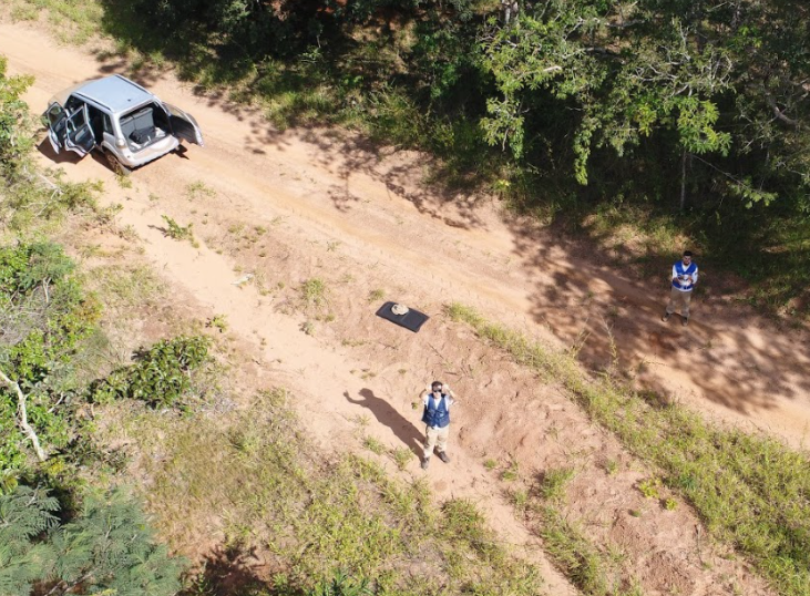
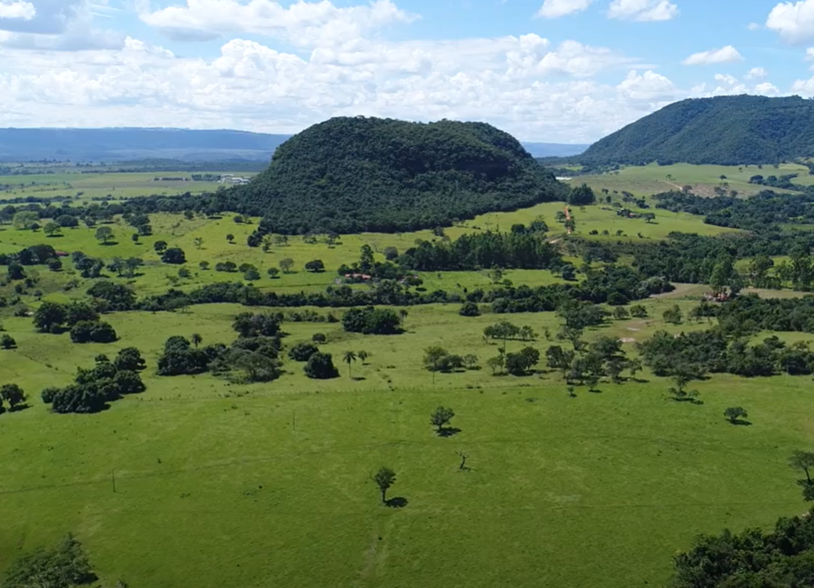
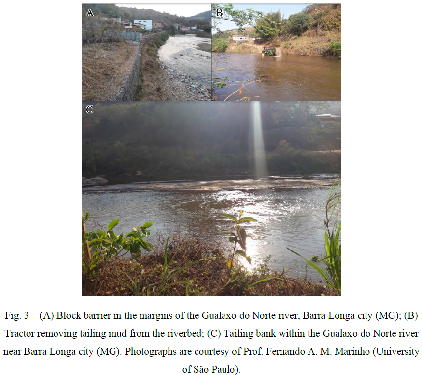
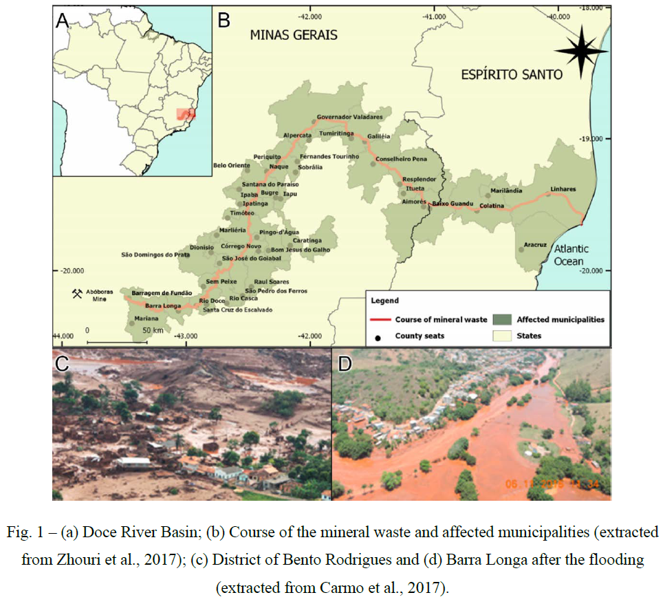
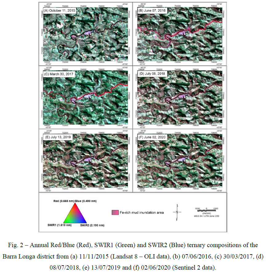
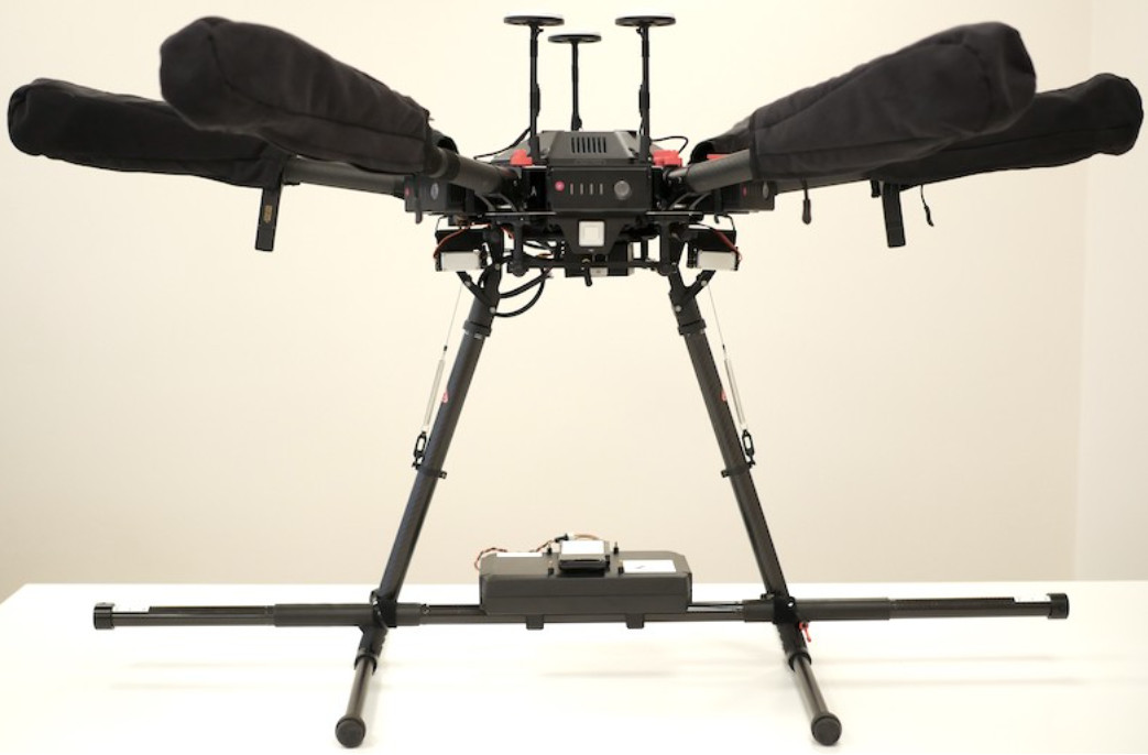
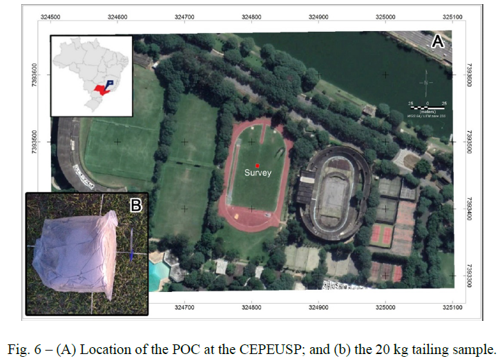
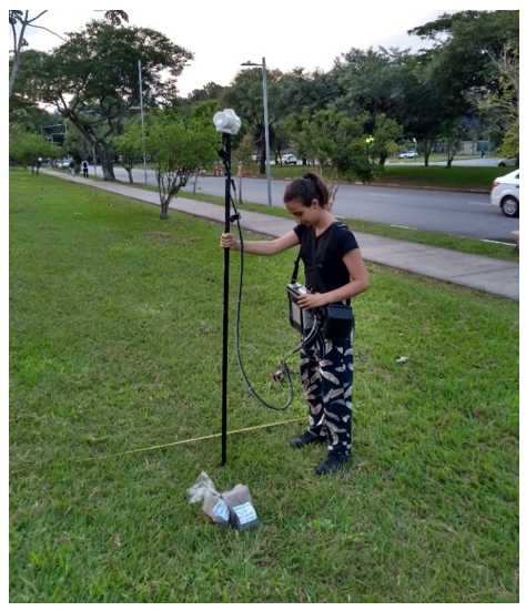
Detection of Fe-rich material from 2015 Mariana disaster using geophysics and geochemistry
The Mariana Disaster, caused by the failure of the Fundão Dam, in 2015 was one of the worst mining-related environmental catastrophes in history. It took 19 lives and compromised the Doce River watershed, home for more than 2 million habitants. The effects of the disaster are still present almost five years later, especially for those who live near the Doce, the Gualaxo do Norte and the Carmo rivers. Several reports describe high concentrations of iron and heavy metals in the water at some areas of the Doce River Hydrographic Basin. Different publications point out that in other regions, the presence of such elements is within the acceptable range defined by the Brazilian Government. The metal concentration in the water is directly associated with the presence of Fe-rich tailings from the Fundão Dam covering the riverbed. This project will search for anomalous tailing accumulations in the Rio Doce Basin rivers using magnetic field data collected on an Unmanned Airborne Vehicle (UAV), and test chemically and isotopically the water, sediments and plants of these areas for iron and heavy metal toxicity. The research group will take the results to the local authorities and the inter-federative committee in charge of restoring the affected area and helping the communities. The population on the most affected areas will be recommended to seek for medical assistance and, when feasible, soil corrections and alternative agricultural measures to avoid further contamination.
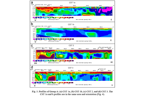
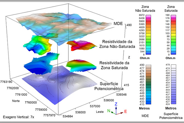
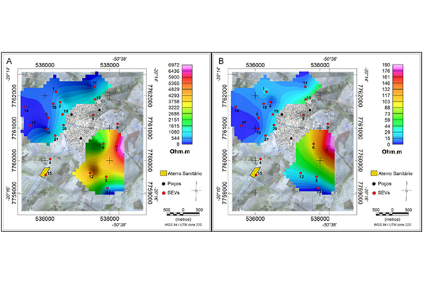
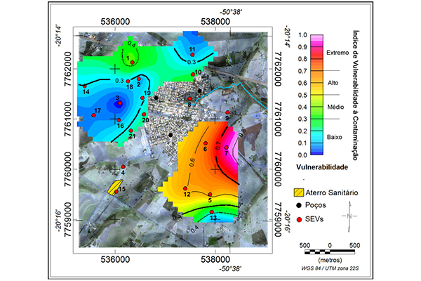
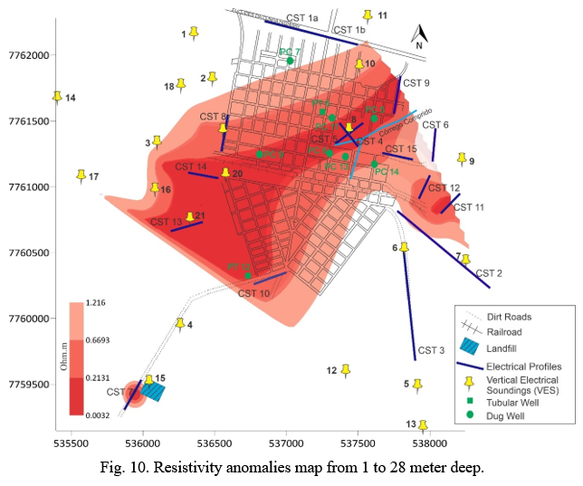
Geophysical Methods in the Analysis of Groundwater Contamination in Urânia – SP
The city of Urânia has been experiencing contamination problems in the Adamantina Aquifer since the 1970s, like many urban areas in São Paulo. It is important to detect and monitor contaminated environments for prevention and repair. However, one of its limitations is the limited access to the aquifer, especially establishing aquifer levels and the lithological characteristics of the unsaturated zone. This work identifies the aquifer recharge areas in Urânia most susceptible to anthropic degradation using electroresistance contrasts. Vertical Electrical Surveys (VES) and Electrical Profiling provided a representative electrical dataset of the municipality. VESs and monitoring wells supported calculating the Dar Zarrouk Longitudinal Conductance Parameter and, further, the vulnerability index. The investigation counted other aquifer characteristics, such as its type, water level and lithology of the unsaturated zone. The resistivity profiles obtained by the Electric Profilings showed values below 0.5 Ohm.m in the northeastern part of the city, close to the aquifer discharge region, where there is a concentration of organic contaminants. The vulnerability map indicated the southeast area as the most prone to contamination due to its permeability, geological material and low thickness of its unsaturated zone. Low-resistivity anomalies were compared to previously published chemical analyzes, corroborating with their assessments and showing the aquifer contaminated areas in and around the urban area of Urânia.